In Short
This guide covers INTERGEO 2026 (September 15-17, Messe München) and what the convergence of GIS, openBIM, and digital twins means for architects, MEP engineers, and AEC firms in India and globally. It explains what INTERGEO is, why it matters to the AEC profession, and covers the three core technology pillars being showcased: GIS as a decision intelligence platform, openBIM's IFC standard as the interoperability bridge, and digital twins as the post-construction evolution of BIM. The guide covers the new Reality Capturing Experience Parc in Hall C5, the Real Estate Lab, and keynote participation by Esri founder Jack Dangermond, alongside a comparison table of key exhibitors and their AEC relevance. It explains how GIS-BIM integration works technically through IFC and CityGML conversion, and what Indian MEP engineers need to do now to position their workflows for digital twin-ready BIM deliverables. Backed by verified 2026 data from INTERGEO official announcements, GIM International, DVW conference program, Global Market Insights, and 360iResearch, this is the most complete INTERGEO 2026 analysis written for the Indian AEC professional audience.
INTERGEO 2026 takes place from September 15 to 17, 2026, at Messe München in Munich, Germany. It's the world's leading trade fair and conference for geodesy, geoinformation, and land management, bringing together over 500 exhibitors from 119 countries and more than 18,500 trade visitors from across the global geospatial and AEC ecosystem (INTERGEO 2026 official announcement). This year's edition has a sharper focus than ever on practical applications: digital twins, GeoAI, reality capture, BIM, earth observation, climate tech, and connected geospatial data infrastructures.
For architects, MEP engineers, and AEC professionals, INTERGEO 2026 matters because it's where the convergence of GIS, openBIM, and digital twin technology gets its clearest annual signal. The global GIS market reached USD 16.95 billion in 2026, growing at a 10.71% CAGR toward USD 31.32 billion by 2032 (360iResearch, 2026). The digital twin market grew from USD 18.9 billion in 2025 to USD 26.4 billion in 2026, on a trajectory toward USD 428.1 billion by 2034 at a staggering 41.7% CAGR (Global Market Insights, 2026). The Architecture, Engineering and Construction sector is registering the fastest growth in 3D mapping and modeling adoption globally (MarketsandMarkets, 2026).
This is not a technology story happening somewhere else. It's reshaping how buildings get designed, documented, coordinated, and managed. And for Indian AEC firms, the tools and workflows being demonstrated at INTERGEO 2026 are arriving in production form, not just as prototypes.
INTERGEO is the world's leading annual event for geospatial technology, geodesy, and land management, organized by DVW e.V., the German Society for Geodesy, Geoinformation and Land Management. It has run for decades and serves as the primary global platform where geospatial technology providers, government agencies, infrastructure firms, AEC companies, and research institutions meet to share developments, announce products, and set the direction of the industry.
INTERGEO matters for AEC professionals because geospatial intelligence is no longer the exclusive domain of surveyors and cartographers. The conference program spans digital twins, BIM, GeoAI, earth observation, gravity fields, smart geodata, extended reality, and geodata-based market and real estate information (DVW INTERGEO Conference Program, 2026). Geodata has become the critical infrastructure for digital planning processes, climate adaptation, energy, mobility, and data-driven decision-making across every sector that touches the built environment.
Jack Dangermond, Founder and President of Esri, delivers a keynote at INTERGEO 2026, the first keynote in the event's history to be open to all ticket holders rather than only registered conference delegates. His participation underlines the event's relevance to the entire geospatial and AEC community. As Dangermond described his participation: "INTERGEO brings together professionals from around the world to share solutions to some of the most pressing location-based challenges of our time. With GIS, we can make more informed decisions for a more sustainable and resilient future."
In 2026, INTERGEO introduces two structural changes that signal where the industry is heading. First, all conference keynotes are open to every ticket holder, bridging the expo and conference communities that have historically operated in parallel. Second, Hall C5 hosts the new Reality Capturing Experience Parc, supported by NavVis, a hands-on area for mobile mapping, laser scanning, photogrammetry, and digital reality capture. The Real Estate Lab, which debuted at INTERGEO 2025, also returns with expanded scope, examining how spatial data is reshaping real estate and urban development decisions.
GIS (Geographic Information System) is no longer a specialist tool for cartographers and surveyors. It is now a decision intelligence platform that processes spatial, temporal, and attribute data to support planning, infrastructure management, environmental monitoring, and built environment operations at city and national scale.
GIS is important in AEC because the built environment exists in a geographic context. A building's energy performance is influenced by its microclimate. A road's structural condition is affected by soil classification. An urban development's flood risk is determined by hydrological data that only a GIS system can model at the required resolution. These connections are invisible in traditional BIM-only workflows.
In March 2026, Esri expanded its AI-powered ArcGIS capabilities to enhance geospatial analytics, digital twin applications, and real-time decision-making for infrastructure, utilities, and public sector organizations (DataM Intelligence, 2026). Autodesk, which commands 17% of the GIS market share, has integrated GIS and BIM workflows so that over 42% of its AEC client base reported improved planning accuracy and reduced site errors from the integration (Global Growth Insights, 2026). Trimble accelerated cloud-based geospatial and AI integrations in February 2026 specifically to improve construction and asset management workflows.
For Indian AEC firms, GIS integration means that site planning, infrastructure design, and urban development projects can draw on real geographic data: soil classification maps, flood zone overlays, existing utility corridors, transportation networks, and environmental clearance zones, all layered into the design environment rather than attached as reference documents that no one updates.
openBIM is the framework of open data standards and workflows that allows BIM data to be exchanged, used, and coordinated across different software platforms without proprietary format lock-in. It is built primarily on the IFC (Industry Foundation Classes) standard maintained by buildingSMART International, and it's the technical foundation on which GIS integration, digital twin creation, and cross-discipline coordination are built.
openBIM matters because the AEC industry has always worked across multiple disciplines using different software tools. Architects use ArchiCAD. Structural engineers use Tekla. MEP engineers use Revit MEP or DesignDrafter. Contractors use project management platforms. Without an open exchange format, each team works from disconnected model exports. openBIM, through IFC, creates a common data language that all of these tools can read, write, and update.
BIM and IFC openBIM can integrate a variety of different data into a single model, including geometric information, performance data, cost details, and more. When integrating this data with GIS, it provides a more complete view of a project, facilitating planning, design, and management.
The current frontier in openBIM is IFC 4.3, which extends the standard to cover infrastructure projects including roads, railways, bridges, tunnels, and ports. IFC 4.3 adoption means that the openBIM workflow that has been standard in building construction can now apply to the full built environment. For AEC firms in India working on infrastructure and civil projects alongside buildings, this extension removes a major interoperability gap.
At INTERGEO 2026, the session program covers connected geospatial data infrastructures and BIM as primary topics, reflecting how thoroughly the geospatial and BIM communities have recognized their convergence. A 2022 bibliometric analysis of 1,879 publications identified BIM-IoT-digital twin convergence as the dominant emerging research cluster in the construction industry (PatSnap BIM Data Integration Landscape, 2026), with openBIM's IFC standard as the interoperability bridge between those converging technologies.
A digital twin is a continuously updated, data-rich virtual representation of a physical asset that enables real-time monitoring, simulation, and decision-making throughout the asset's lifecycle. In the AEC context, a digital twin is what a BIM model becomes when it stays connected to the real building after construction: updated with IoT sensor data, occupancy patterns, energy meter readings, maintenance records, and environmental conditions.
Digital twins are important because they shift the value of BIM from a construction-phase tool to a lifecycle asset management platform. A building with a connected digital twin can predict maintenance failures before they occur, optimize energy performance against real occupancy data, comply with ECBC performance requirements post-occupancy, and provide facility managers with a spatial interface to their building systems.
The digital twin market is growing at a 41.7% CAGR, from USD 26.4 billion in 2026 toward USD 428.1 billion by 2034 (Global Market Insights, 2026). Europe, which hosts INTERGEO, is the second-largest regional market for digital twins, growing at 41% CAGR driven by government smart city programs and Industry 4.0 initiatives. At INTERGEO 2026, digital twins appear across multiple session tracks: urban digital twins for city planning, building digital twins for real estate management, infrastructure digital twins for roads and utilities, and climate digital twins for environmental monitoring.
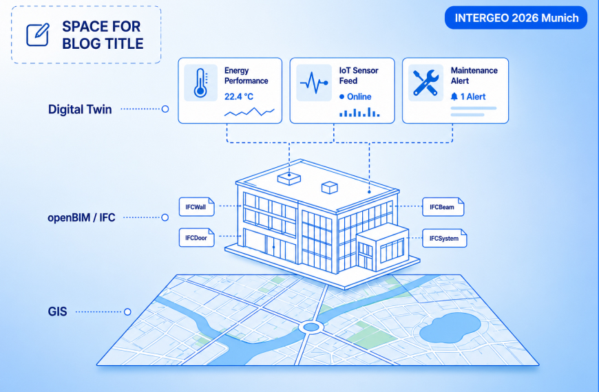
The convergence of GIS, openBIM, and digital twins creates what researchers are calling the Geo Digital Twin: a model that integrates building-level BIM data with city-scale GIS data in a dynamic, bidirectional system where changes in the physical building update the GIS map in real time, and geographic context data informs building-level decisions continuously.
One of the most significant new features at INTERGEO 2026 is the Reality Capturing Experience Parc in Hall C5, supported by NavVis and partnered with 3DISE. This hands-on area brings together technologies for mobile mapping, laser scanning, photogrammetry, and digital reality capture in a live comparison environment.
Reality capture is the process of converting the physical world into accurate digital data through scanning, photography, and sensor fusion. It's the entry point for both digital twin creation and openBIM as-built documentation. When a building is scanned with a LiDAR scanner or mobile mapping device, the resulting point cloud becomes the geometric basis for an as-built IFC model that connects directly to GIS and digital twin workflows.
For AEC professionals, reality capture matters at two specific project stages. First, during existing building renovation or retrofit projects, where no accurate as-built drawings exist and a scan-to-BIM workflow converts the point cloud into a structured Revit or IFC model. Second, during construction monitoring, where regular scans compare the as-built condition to the design model, flagging deviations that would otherwise be discovered at handover.
Visitors at INTERGEO 2026 will experience how real-world environments are digitally captured and transformed into actionable data models, live, hands-on, and through direct comparison of different technologies. The Experience Parc also includes a Reality Capture Hub providing visibility for companies and innovators in the reality capturing community, fostering exchange and new business opportunities alongside the main exhibition.
GIS and openBIM integration works by creating a bidirectional data link between an IFC model in a BIM environment and a GIS platform like Esri ArcGIS, so that changes in the BIM model update the GIS map in real time and geographic data from the GIS system informs decisions in the BIM environment.
This approach allows those managing real estate assets and infrastructure to always have up-to-date data on the GIS map, with obvious advantages in terms of management and maintenance of infrastructures. The ability to view real-time changes made to BIM models within the geographic context of GIS offers significant added value, improving the efficiency and precision of operations.
The technical bridge between the two systems is the IFC open standard. When a building's IFC model is published to a Common Data Environment (CDE), changes to the BIM model automatically propagate to the linked GIS layer. A building's floor area changes in the Revit model? The GIS system's property database updates automatically. A new building is added to a development? Its geolocation and footprint appear in the urban planning GIS immediately.
In practice, for Indian AEC firms, this integration has three specific applications:
The BIM software market reached USD 8.6 billion in 2023 and is projected to reach USD 24.8 billion by 2030 at a 16.3% CAGR (BuildTwin, 2026). As BIM adoption becomes near-universal among large AEC firms (90%+ for firms with 100+ employees), the next competitive differentiation will come from GIS and digital twin integration.
India's AEC market is growing rapidly. The country's construction sector is expected to grow significantly through 2030, driven by infrastructure investment, urbanization, and smart city programs. But Indian AEC firms have been slower to adopt the GIS-openBIM-digital twin convergence that INTERGEO 2026 is showcasing, primarily because the tools have historically been complex, expensive, and poorly integrated for Indian project conditions.
Three specific signals from INTERGEO 2026 matter directly for Indian AEC professionals:
GeoAI, the combination of geospatial data with artificial intelligence, is a primary conference theme at INTERGEO 2026. In March 2026, Esri implemented machine learning-driven land cover classification in ArcGIS Living Atlas, updated daily from satellite imagery. AI-powered geospatial analytics are moving from research to production at a pace that means Indian firms evaluating AI tools for design and planning need to include geospatial AI in their assessment, not just AI tools for BIM and drawing automation.
From the INTERGEO 2025 retrospective, panelists including leading AEC and geospatial professionals agreed: "AI models will improve enormously, LLMs are big today, but there is a trend to more AEC-specific data models. AI without geodata doesn't make sense: it needs the context" (LIDAR Magazine, 2025). That context-dependency is exactly why GIS and BIM are converging rather than competing.
The key infrastructure decision for any Indian AEC firm considering digital twin or GIS integration is whether their BIM tools export clean IFC data. If they do, the entire GIS, digital twin, and multi-platform coordination ecosystem opens up. If they don't, every integration becomes a custom engineering exercise.
DesignDrafter's CAD-to-BIM workflow produces structured, IFC-compatible Revit models from existing CAD drawings, which is the starting point for any GIS or digital twin integration for Indian firms with legacy CAD archives. The DesignDrafter BIM software complete guide covers what IFC-compatible BIM workflows mean in practice for Indian AEC teams transitioning from CAD to connected digital workflows.
The most important long-term implication of INTERGEO 2026 for Indian AEC firms is this: clients are beginning to ask for digital twin deliverables alongside construction documentation. Data centers, airports, hospital campuses, and smart city infrastructure projects increasingly specify that the BIM model must stay live after handover, connected to IoT sensors and facility management systems.
Firms that understand how to produce an IFC model that's clean enough to serve as a digital twin foundation are positioned to offer this as a service. Firms that don't have that capability will lose the long-term facility management opportunity to firms that do.
The DesignDrafter MEP in construction complete guide covers how MEP calculations and BIM outputs need to be structured to support digital twin readiness from the design stage.
INTERGEO 2026 features exhibitions and conference sessions from the leading players in BIM technology with geospatial integration. Here's what the key companies are bringing to Munich:
| Company | INTERGEO 2026 Focus | AEC Relevance |
|---|---|---|
| Esri | GeoAI, ArcGIS digital twin expansion, real-time location intelligence | GIS-BIM integration, urban planning, smart city applications |
| Trimble | Cloud geospatial AI, Tekla BIM, construction positioning | IFC-based construction coordination, digital twin readiness |
| Hexagon AB | Smart reality capture, autonomous mapping, cloud GIS analytics | Scan-to-BIM, as-built digital twins, infrastructure monitoring |
| Bentley Systems | Digital twin features in GIS suite, OpenRoads, infrastructure BIM | 47% adoption among utilities for real-time asset management |
| NavVis | Reality Capturing Experience Parc sponsor, indoor mapping | Facility-level digital twins, as-built documentation |
| Schneider Digital | ImmersaXR-Studio launch for 3D stereo and XR workflows | Immersive geospatial visualization, point cloud review |
| Autodesk | ArcGIS-BIM integration, GIS interoperability, smart city applications | 42% of AEC clients reported improved planning accuracy |
For MEP engineers specifically, the GIS-openBIM-digital twin convergence means that MEP systems are no longer designed and documented in isolation from their geographic and urban context.
Consider a hospital MEP design in an urban area. Traditional MEP design focuses entirely on the building boundary. The GIS-connected digital twin model extends that scope: the hospital's water supply connects to the municipal network whose pressure and capacity are modeled in the GIS system. The electrical load connects to the grid, whose stability data is available in real time. The HVAC system's performance is benchmarked against actual urban heat island data from the GIS layer, not a generic climate zone assumption.
This isn't speculative technology. Woolpert, described by LIDAR Magazine as an AEG (architecture, engineering, and geospatial) company, presented at INTERGEO 2025 with airborne acquisition systems that create the geospatial data foundation for exactly these integrated building and infrastructure models. Companies like Woolpert have already expanded to 75 global offices specifically to serve the convergence of AEC and geospatial workflows.
For Indian MEP engineers, the practical starting point is producing clean, IFC-standard BIM outputs from MEP calculations. This means MEP design tools must connect calculation results to structured BIM geometry, not just drawing files. The DesignDrafter MEP consultant solution produces HVAC, electrical, plumbing, and fire fighting calculation outputs connected to BIM-ready drawings, which is the technical prerequisite for any GIS or digital twin integration downstream.
The DesignDrafter MEP drawing software vs. design software guide explains why the connection between calculation and structured drawing output is the foundational requirement for digital twin-ready MEP documentation.
INTERGEO 2026, running September 15-17 in Munich with 500+ exhibitors from 119 countries, is the clearest annual signal of where geospatial technology and AEC are converging. This year's event demonstrates that the GIS-openBIM-digital twin integration is no longer an emerging concept. It's production-grade technology being deployed at scale across infrastructure, real estate, urban planning, and built environment management globally.
The core takeaway for architects and MEP engineers is straightforward: the AEC industry is shifting from building-scale digital workflows to geographic-scale connected intelligence. BIM that doesn't produce clean IFC output can't participate in GIS integration. MEP calculations that don't connect to structured BIM geometry can't serve as the foundation for digital twins. Documentation workflows that end at permit submission can't deliver the living models that clients and facility managers increasingly expect after handover.
For Indian AEC firms, three immediate priorities follow from what INTERGEO 2026 is showcasing. First, ensure your BIM outputs are IFC-compatible, which starts with using platforms that produce structured, object-based Revit or IFC models rather than flat CAD drawings. Second, understand how GIS context data can improve the accuracy of your design decisions, particularly for infrastructure, urban development, and master planning projects. Third, begin designing MEP systems with digital twin readiness in mind, which means calculation outputs connected to BIM geometry, not produced in parallel tracks that never share data.
DesignDrafter's CAD-to-BIM conversion, connected MEP calculation and drawing output, and IFC-compatible BIM workflow position Indian AEC firms to participate in the GIS-openBIM-digital twin ecosystem that INTERGEO 2026 is demonstrating.
References & sources
Citations that back the claims in this post.
INTERGEO 2026 official event (GIM International)
gim-international.com
DVW INTERGEO 2026 Conference Program
dvw.de
Global Market Insights Digital Twin Market
gminsights.com
Founder
Manas Krishna is a Mechanical Engineer and infrastructure technology entrepreneur with 20+ years of experience in MEP (Mechanical, Electrical, and Plumbing) engineering, public health engineering, and transport infrastructure projects across India.
FAQ

INTERGEO 2026 is the world’s leading trade fair and conference for geodesy, geoinformation, and land management. It takes place from September 15 to 17, 2026, at Messe München in Munich, Germany, in Halls B5, B6, C5, and C6. The event brings together over 500 exhibitors from 119 countries and more than 18,500 trade visitors. The conference program covers digital twins, BIM, GeoAI, earth observation, climate tech, and connected geospatial data infrastructures. The opening keynote by Esri founder Jack Dangermond is open to all ticket holders for the first time.
openBIM is a framework of open data standards, primarily the IFC (Industry Foundation Classes) format maintained by buildingSMART International, that allows BIM data to be exchanged across different software platforms without proprietary format restrictions. It connects to GIS through the IFC standard: an openBIM model published in IFC format can be imported into GIS platforms like Esri ArcGIS, creating a bidirectional link where changes to the BIM model update GIS data in real time. This integration is the technical foundation for geospatial digital twins.
A digital twin in AEC is a continuously updated virtual representation of a physical building or infrastructure asset that stays connected to the real asset after construction through IoT sensors, operational data, and real-time updates. A BIM model is a design and documentation tool used primarily during the project lifecycle. The digital twin extends BIM into operations: it monitors energy performance, predicts maintenance failures, and enables facility management through a spatial interface. The digital twin market is growing from USD 26.4 billion in 2026 to USD 428.1 billion by 2034 at a 41.7% CAGR.
INTERGEO 2026 is important for AEC professionals because it demonstrates the state of production-ready GIS, openBIM, digital twin, and reality capture technology that is reshaping infrastructure design, urban development, and facility management globally. The event signals where the industry is heading: toward geographic-scale connected intelligence where BIM data, GIS context, IoT sensor feeds, and AI analytics work together in a single digital environment. The AEC sector is registering the fastest growth in 3D mapping and modeling adoption globally, and INTERGEO is where that growth trajectory gets its clearest annual picture.
The Reality Capturing Experience Parc is a new hands-on innovation area in Hall C5 at INTERGEO 2026, supported by NavVis. It brings together technologies for mobile mapping, laser scanning, photogrammetry, and digital reality capture in a live comparison environment where visitors can see competing approaches applied to the same use cases side by side. A companion Reality Capture Hub, in partnership with 3DISE, provides additional visibility for companies and innovators in the reality capturing community. Reality capture is the entry point for scan-to-BIM, as-built documentation, and digital twin creation.
GIS improves BIM workflows by providing geographic context that building-scale BIM cannot model: soil classifications, flood zones, utility corridor data, traffic and transport networks, environmental constraints, and urban heat island effects. For infrastructure projects like roads, railways, and utility networks, GIS provides the territorial scale that IFC-based BIM handles at the asset level. Autodesk reports that 42% of its AEC clients reported improved planning accuracy and reduced site errors after integrating GIS with BIM workflows. The BIM-to-GIS pathway using IFC to CityGML conversion is currently the dominant integration method.
IFC (Industry Foundation Classes) is the open data exchange standard that connects BIM models to GIS systems and digital twin platforms. When a BIM model exports in IFC format to a Common Data Environment, changes made in the BIM authoring tool (such as Revit or DesignDrafter’s BIM output) update the IFC file, which in turn updates the linked GIS map. This bidirectional integration creates the geospatial digital twin, where building-level data stays current across both the BIM and GIS environments. IFC 4.3 extends this capability to infrastructure including roads, railways, and bridges.
INTERGEO 2026 showcases BIM technology convergence with GIS, digital twins, GeoAI, and reality capture as the dominant trends. Key developments include Esri’s expanded ArcGIS digital twin capabilities, Trimble’s Tekla 2026 with AI fabrication drawing generation, Hexagon’s smart reality capture and cloud GIS analytics, Bentley Systems’ digital twin features for infrastructure and utilities, and NavVis’s indoor mapping for facility-level digital twins. The broader theme is the shift from BIM as a construction-phase tool to BIM as the data foundation for connected, AI-driven built environment management.
Indian MEP engineers should take three immediate steps to prepare for the GIS and digital twin shift. First, ensure MEP calculations connect to structured BIM geometry (not just flat drawings) using platforms like DesignDrafter that produce IFC-compatible outputs. Second, understand IFC export from their BIM tools, as clean IFC data is the prerequisite for any GIS integration or digital twin workflow. Third, design systems with facility management in mind, including standardized equipment naming, sensor accommodation in design, and connection scheduling that can feed a building management system after handover.
GeoAI is the combination of geospatial data processing with artificial intelligence, applying machine learning to spatial datasets for applications including automated land cover classification, infrastructure risk assessment, urban growth prediction, and real-time environmental monitoring. In AEC, GeoAI affects site selection by analyzing geographic risk data, infrastructure planning by predicting load and capacity needs from urban growth models, and facility management by integrating environmental sensor data with building performance analytics. In March 2026, Esri implemented machine learning-driven daily land cover updates in ArcGIS Living Atlas, a clear signal that GeoAI has moved from research to production deployment.
May 8 , 2026
March 12 , 2026
May 15 , 2026